
ملف:2022 Russian invasion of Ukraine.svg

الصوره الاصليه (ملف SVG، اساسا 2,199 × 1,478 بكسل، حجم الملف: 3.73 ميجابايت)
Rules for editing the map
|
| سيُمنع مباشرةً أي حساب يُزكي حروب التحرير أو يرفع نسخة جديدة تعتمد على مصادر غير موثوقة. يلزم نقاش أي تغيير أولاً في صفحة نقاش الملف. |
الخلاصة

|
This file may be updated to reflect new information. If you wish to use a specific version of the file without new updates being mirrored, please upload the required version as a separate file. |
| وصف | |||
| تاريخ | 24 فبراير 2022 (first version) | ||
| مصدر |
Own work based on: Russo-Ukrainian conflict (2014-2022).svg مِن Rr016 & Ukraine adm location map improved.svg مِن Yakiv Gluck
|
||
| مؤلف | Viewsridge | ||
| إصدارات أخرى |
[]
|
||
| SVG منشأ الملف | الشيفرة المصدرية لهذا الرسم المتجه صالحة. .هذا الرسم المتجهي أُنشئ بواسطة Inkscape This map is translated using SVG switch elements: all translations are stored in the same file.
|


.gif)

.gif)


_en.png)
_vi.png)
_ru.png)
.svg)
This file is translated using SVG <switch> elements. All translations are stored in the same file! Learn more.
For most Wikipedia projects, you can embed the file normally (without a To translate the text into your language, you can use the SVG Translate tool. Alternatively, you can download the file to your computer, add your translations using whatever software you're familiar with, and re-upload it with the same name. You will find help in Graphics Lab if you're not sure how to do this. |
الترخيص
- إنت حر:
- فى المشاركه – علشان نسخ و توزيع و بث العمل
- إنك تمزج – فى تكييف العمل
- بالشروط دى:
- نسبه ل – لازم يتنسب العمل للى مألفه بشكل مناسب و توفير رابط للرخصه وتحديد اذا حصلت تغييرات. ممكن ده يتعمل بأى طريقه معقوله، لكن مش بطريقه تشير ان مانح الرخصه بيوافقك على الاستعمال.
- مشاركه زي – لو عدت إنتاج المواد أو غيرت فيها، لازم تنشر مساهماتك اللى جايه من الأصل تحت ترخيص الأصل نفسه أو تحت ترخيص متوافق معاه.
تاريخ الفايل
اضغط على الساعه/التاريخ علشان تشوف الفايل زى ما كان فى الوقت ده.
| الساعه / التاريخ | صورة صغيرة | ابعاد | يوزر | تعليق | |
|---|---|---|---|---|---|
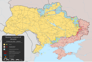
| دلوقتي | 20:28، 10 يونيه 2024 | | 2,199 × 1,478 (3.73 ميجابايت) | Physeters | Updates across the front per the ISW; Russia re-enters Sumy Oblast & recaptures Staromaiorske in Donetsk Oblast |
| 07:11، 27 مايو 2024 |  | 2,199 × 1,478 (3.73 ميجابايت) | Physeters | clean up; for future reference, only the red shaded areas on the ISW map are shown as Russian controlled on this map | |
| 09:14، 26 مايو 2024 |  | 2,199 × 1,478 (3.72 ميجابايت) | Hoben7599 | Per ISW | |
| 11:16، 22 مايو 2024 |  | 2,199 × 1,478 (3.32 ميجابايت) | Hoben7599 | File uploaded using svgtranslate tool (https://svgtranslate.toolforge.org/). Added translation for zh-hant. | |
| 05:49، 21 مايو 2024 |  | 2,199 × 1,478 (3.72 ميجابايت) | Physeters | Updates per the ISW, update Staromaiorske, Klishshchiivka, and Robotyne per the detailed map | |
| 04:00، 18 مايو 2024 |  | 2,199 × 1,478 (3.72 ميجابايت) | Physeters | Fix Bohudukhiv | |
| 20:47، 16 مايو 2024 |  | 2,199 × 1,478 (3.72 ميجابايت) | Physeters | Updates in Kharkiv Oblast per the ISW | |
| 04:40، 14 مايو 2024 |  | 2,199 × 1,478 (3.72 ميجابايت) | Physeters | fix Derhachi | |
| 05:36، 13 مايو 2024 |  | 2,199 × 1,478 (3.72 ميجابايت) | Alexiscoutinho | Updated Vovchansk per detailed map | |
| 02:49، 13 مايو 2024 |  | 2,199 × 1,478 (3.72 ميجابايت) | Physeters | Updates per the ISW; for future reference, sources (like SuriyakMaps) must first have their reliability vetted on the talk page before they can be used to update the map; at the moment, the only two verified sources are the ISW and the Detailed Map on Wikipedia |
استخدام الفايل
ال1 صفحة دى فيها وصله للفايل ده:
استخدام الملف العام
الويكيات التانيه دى بتستخدم الفايل ده:
- الاستخدام ف af.wikipedia.org
- الاستخدام ف als.wikipedia.org
- الاستخدام ف am.wikipedia.org
- الاستخدام ف ang.wikipedia.org
- الاستخدام ف an.wikipedia.org
- الاستخدام ف ar.wikipedia.org
- الاستخدام ف ary.wikipedia.org
- الاستخدام ف ast.wikipedia.org
- الاستخدام ف azb.wikipedia.org
- الاستخدام ف az.wikipedia.org
- الاستخدام ف bat-smg.wikipedia.org
- الاستخدام ف bcl.wikipedia.org
- الاستخدام ف be-tarask.wikipedia.org
- الاستخدام ف be.wikipedia.org
- الاستخدام ف bg.wikipedia.org
- الاستخدام ف bh.wikipedia.org
- الاستخدام ف bn.wikipedia.org
- الاستخدام ف br.wikipedia.org
- الاستخدام ف bs.wikipedia.org
- الاستخدام ف bxr.wikipedia.org
- الاستخدام ف ca.wikipedia.org
اعرض استخدام عام اكتر للملف ده.